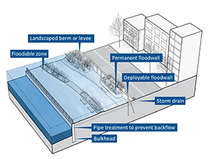
NYC Coastal Protection Plan
Mayor Michael Bloomberg has announced his proposal protect the NYC coastline from floodwaters. Click the features below to show levees, gates and other barriers.
New York City Special Initiative for Rebuilding and Resiliancy.
Not shown are areas of "beach nourishment," or sand addition, along the coastlines of the Rockaways, Coney Island and eastern Staten Island.
https://project.wnyc.org/planyc-map/
Embed This
<iframe frameborder="0" scrolling ="no" src="https://project.wnyc.org/planyc-map/" width="100%" height="785" ></iframe>
Steve Melendez, Louise Ma, John Keefe and Joe Geogan / WNYC Data News Team. Follow us @datanews, email us here.
The WNYC Data News Team is part of a public radio station supported by audience contributions. If you like what you see, consider supporting our work.
- Data
- Embed
- Fullscreen
- Credits
- Story
NYC Coastal Protection Plan
Mayor Michael Bloomberg has announced his proposal protect the NYC coastline from floodwaters. Click the features below to show levees, gates and other barriers.