WNYC Data News Tools (Feb 2018)
Criminal court case search
We can search convicted criminal court cases in the NYC area (12 counties) using our copy of CRIMS (Criminal Record Information and Management System). Fields include defendant's name, arresting officers, defense attorney names, charges, dispositions and sentences. CRIMS data is a good resource for leads or to help verify information. It SHOULD NOT be reported out directly without careful consideration. Email your question to *DataNews, or find a member of Data News.Bots - automate reporting tasks
- Track changes: We can set up an alert for when a web page changes. We commonly do this for updates on PACER in federal court cases.
- Download files as they're updated: We can help you save a copy of data that updates regularly. Examples include daily school attendance data and weekly crime stats.
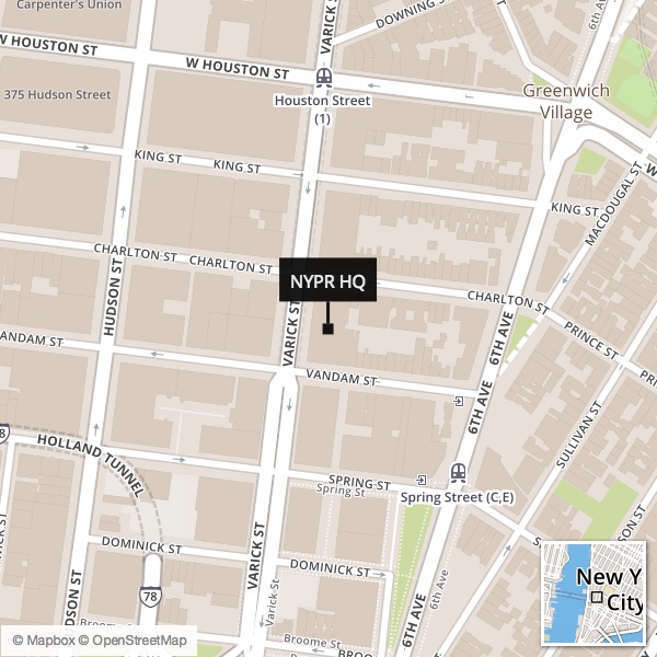
Locator Map Builder
Embeddable Tools
Weather
Warnings
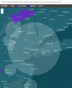
Live Weather Service warnings, with WNYC/NJPR coverage areas.
Last updated: Every 1 minute
Made for internal WNYC use only. Link: https://project.wnyc.org/dashboard-warnings/
Storm Radar

Current National Weather Service radar for the entire US.
Hurricane Tracker
Automatically tracks every named Atlantic cyclone.
Evacuation Zones
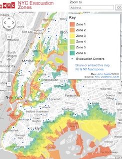
Official NYC evacuation maps, searchable.
Last updated: July 2013
Link:
https://project.wnyc.org/hurricane-zones/hurricane-zones.html
Flood Gauges
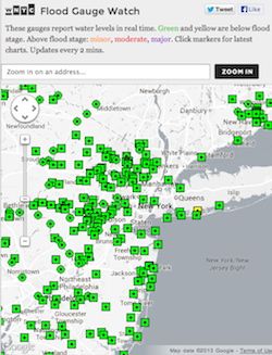
Current river & coastal flooding.
Last updated: Every 2 mins
Transportation
Transit Time NYC
Travel times by subway from any point.
Last updated: July 2013 (still valid May 2015)
Link: https://project.wnyc.org/transit-time/Transit Tracker
Status of all NYC-area transit services.
Updated: During storms and civic emergencies.
Live Traffic
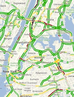
Current road traffic status from Google. Great for holidays.
Last updated: Real time
Economics
Median Income Nation
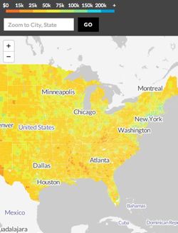
National Median Income Map, by county.
Last updated: 2012 5-Year ACS data.
NYC Change in Median Income
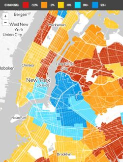
Change in median income across NYC from 2007-2009 to 2010-2012.
Last updated: 2007-2009 and 2010-2012 ACS data.
NYC Median Income

Median income by census tract.
Last updated: 2011 ACS
New New Yorkers
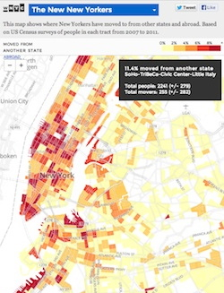
Where the newest New Yorkers live.
Last updated: 2012 with 2011 ACS data
NYC Rent Burden
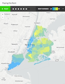
The median portion of income spent on rent & utilities increases across many neighborhoods.
Last updated: 2006-2011 data
Diversity in NYC

We use USA Today's "Diversity Index" to calculate diversity in NYC's census tracts.
Last updated: 2010 Census
Recession Recovery

Rebound of jobs after each recession.
Last updated: December 2013 data
Education
Graduation Rates
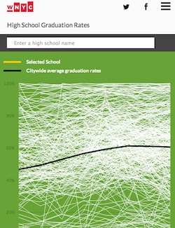
For every NYC high school, on one chart.
Last updated: 2015 data