
On a recent Saturday at the Staten Island Children’s Museum, a group of kids giggled as they slowly climbed the stage to join Ready Girl, a superhero whose special power is, well, readiness. She’s the brainchild of Katelyn James, an outreach coordinator at the New York City Office of Emergency Management OEM. Ready Girl’s mission is part of a wider educational outreach campaign to spread the word about all the measures taken by the city to better prepare residents for dangerous weather since Sandy wreaked havoc here five years ago.
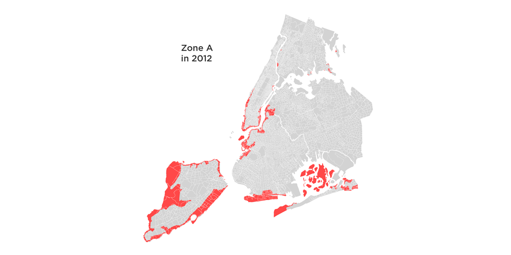
The city redrew the evacuation map in 2013, adding greater detail and increasing the number of zones from three to six. The city also expanded the reach of their mobile alerts platform. Alerts can now be delivered by the same cellphone system used for Amber alerts and other emergency warnings.
But research conducted by the city indicates there’s more work yet to be done. A recent poll conducted by the Global Strategy Group found that one in four residents don’t know if they live in an evacuation zone, and over half of those that do know can’t say which one. But there may be a bigger problem than that. A survey conducted after Sandy by the same group found that 63 percent of city residents living in the mandatory evacuation zone at the time of the storm chose not to leave.
Respondents gave many reasons why they chose to stay, but the top one was that despite the overwhelming information coming from the media and public officials, they believed the storm wouldn’t be that strong. Researchers warn that increasing the availability of information does not ensure people will use it to make decisions. To address this, communities are beginning to organize smaller groups of trusted neighbors to spread information. The thinking is that when it’s time to go, a knock on the door from a neighbor is more likely to lead someone to safety during extreme weather.
Learned Helplessness
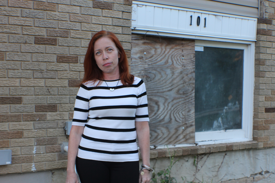
As Sandy moved closer to Staten Island five years ago, Roseanne Dempsey, a longtime resident of the Midland Beach neighborhood, closely followed the news. “The more you watch the news, the more panic you feel they create. You don't know whether to heed the warnings, not heed the warnings, is it too late to heed the warnings?” Dempsey says. In this state of confusion, Dempsey decided to keep her two daughters, elderly parents and dog home during the storm.
Reflecting on her decision, Dempsey says, “We thought at most there would be a foot or two of water. We’ve lived in this house for 40 years. We had only gotten a little bit of water in the basement. So we didn't evacuate like we probably should have. Until we saw the water rushing down the street from the beach, we didn't realize how much trouble we were in.”
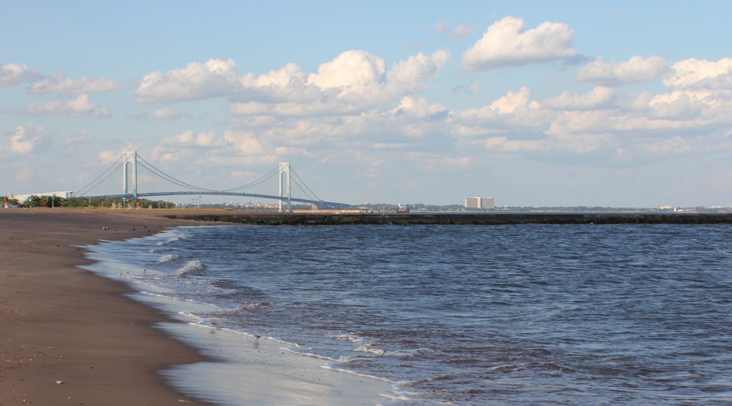
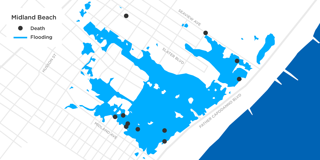
As the water rushed into their home, the family ran upstairs. Thankfully, the water did not reach them, but the entire basement and first floor of their home was flooded. As the night progressed, Roseanne recalls, “I just kind of went to sleep; it was kind of like a catatonic state.” The next morning, the family was rescued by a FDNY lifeboat. Higher ground was only a couple of blocks away, where they were loaded onto a school bus to go to the nearest shelter. Not all were as fortunate: Of the 44 people who died in New York City during Sandy, 25 percent died in Dempsey’s neighborhood.
Rev. Katie Cumiskey is an interfaith minister, chair of the College of Staten Island CSI CUNY Psychology Department and a resident of Staten Island. She worked as a crisis counselor in the community after Sandy. “We kind of have this New Yorker survivor attitude,” she says. However, Dempsey and her family did evacuate a year earlier when Tropical Storm Irene threatened the area. Dempsey’s family, along with many others in her neighborhood, figured they would be fine because nothing happened to them during Irene. “A lot of people stayed because of what happened the year before. No one was really as worried because they were like, ‘Oh, what’s going to happen? How many times am I going to do this?’” Dempsey says.
Cumiskey explains one of the most difficult barriers to perceiving threat is the notion of false alarms. “What we know from research is that direct experience often takes precedence over vicarious experience or just plain information without experience. In psychological literature we call it ‘learned helplessness,’ which is that difficulty we have to exert effort after a failed attempt at something. This was at play when preparedness for Irene seem to be a lot of exertion for nothing. That then made it harder for people to take the warnings related to Sandy seriously.”
Availability and use
The New York City Office of Emergency Management is charged with communicating actionable information to residents. In the year after Sandy, they redrew their evacuation map and increased the zones from three to six. As a result, 600,000 more New Yorkers now live in flood zones.
The city also extended the reach of their mobile notifications system adding the capability to send Wireless Emergency Alerts in addition to the Notify NYC system. The office also uses workshops, advertisements and Ready Girl to get the word out. The message is clear enough: Make a plan, stay informed and know your evacuation zone before severe weather happens.
Herman Schaffer, the Assistant Commissioner for Community Outreach at the OEM, says the challenge facing the office each year is to come up with new ways to get the right information to citizens.
“We look at the number of people who come to our presentations and the number of guides that our people requested. We have all the metrics about our ad campaign and how many people visit us on our website and social media accounts. We can look at all that, but one thing that we know is that a lot of people still don't know. People don't have the information. It's not because it's not available but because they haven't decided to make it a part of their lives. So every single year, we realize we have a big job to do.”

Mobile notifications are an effective channel to distribute information as widely as possible, but there are limitations during a storm. Alexandra Coym, associate creative director at the design firm frog, has worked with the United Nations to improve data delivery during emergencies. “The mobile phone is a great way to reach people in an emergency situation. It's very accessible for most people, they have it on hand all the time. At the same time it's potentially also short-sighted. If the first thing that goes down is the power lines and the communication towers, there's no way to reach people over phones,” Coym says.

In addition to her work as a counselor, Rev. Katie Cumiskey also studies the psychological effects of mobile technology. “Mobile technology has given us a lot of access to information, but there's almost a way in which that access to information diminishes our initiative in being prepared. We feel that it's thinking for us or that we're invincible because of it,” she says.
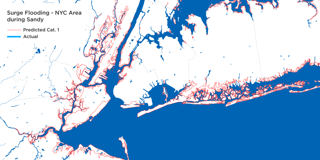
Still, even when residents are aware of their zone and make an action plan for how they would evacuate during a weather emergency, researchers say people often are confused by the different kinds of warnings they receive. As a result, people sometimes perceive dangerous weather as non-threatening and fail to take appropriate safety measures. Storm surge, for example, might be interpreted by the public as the same type of flooding experienced during thunderstorms – that is, an annoyance rather than the sudden rush of the ocean onto land.
A further complication faces forecasters. “The challenge is when you have situations where there’s increased risk for multiple types of flooding at the same time,” Andrew Kruczkiewicz, a climate researcher at the International Research Institute for Climate and Society at Columbia University’s Earth Institute, says. “The area of greatest impact is not necessarily always going to be at that initial location of landfall.”
There’s a gap, Kruczkiewicz says, between the availability of the information forecasters, the media and city officials are presenting to the public, and the use of that information by people in danger to make better decisions about their safety. Increasingly, researchers and community groups are working to design smaller local networks led by trusted messengers to deliver information in an emergency.
The need for trusted communication
The city currently sees its role as continuing to raise awareness with tools like the Ready Girl program, and to give presentations and training sessions for community organizations and nonprofits. Kruczkiewicz conducted research on the ground after Sandy, however, and discovered something interesting. Many of those who evacuated before Sandy hit did so because they received information from a local source in their neighborhood. His findings showed that fishermen and surfers were some of the most trusted sources for information. As longtime residents of the community, he says, they’re perceived to be people who have a relationship with the sea and deep knowledge of the weather.
“Even if the information is available and even if the information is clear, it doesn't necessarily mean action is going to be taken unless there's some other force to establish a deeper, more emotional connection,” Kruczkiewicz says. “And many times that connection comes from trust: the idea that the person repackaging or telling that information really just gets the community and understands what's happening in that community.”
This approach resonates with the city’s Office of Emergency Management. “A lot of this is individual responsibility for making plans. A lot of this is community responsibility for making the effort. What we found is when we’ve come in and said, ‘OK, this is the structure for your community,’ we're not getting it right because we don't live there,” Schaffer says. “Preparedness is always a shared responsibility. We can give you all the resources, but if you don't make that plan, that's really where we stop. These are all decisions based on your specific needs and your specific situation. Communities are much the same.”
To this end, about 60 community organizations and nonprofits have joined a new network the city is building. The goal is to provide training for local groups in how to distribute official information before a storm. In Staten Island, the two main groups working with the city are the Staten Island Community Organizations Active in Disaster COAD and the Staten Island Long Term Recovery Organization LTRO, which is specifically focused on the neighborhood level. But back in Midland Beach very little has been implemented.
A pilot project was started in 2014 to train “block captains” who would communicate with their neighbors before an emergency, but no block captains are currently in place. According to Karen Jackson, coordinator for LTRO, the project lacks funding. “There have been so many disaster preparedness workshops over the last five years I think people are done,” Jackson says. “If the future of disaster preparedness and response is in helping the city communicate with on-the-ground leaders and nonprofits, then funding for coordinator positions is the way forward to help that communication happen.”
Jackson’s concerns are echoed across the city. In the Bronx, the NYC Environmental Justice Alliance and The Point CDC recently held a community-organizing workshop to practice what they would do in a weather emergency. Angela Tovar, Director of Community Development at The Point CDC, says work on the neighborhood level is still in the preliminary stage. “We’re going to need a wide range of resources. A lot of it is about improving our own communication system here. Social resiliency is key,” Tovar says. “It’s great that the city has put out these resources, but we need a lot of help with both financial resources and technical assistance to do this kind of work,” says Pamela Soto, a research analyst for the New York City Environmental Justice Alliance.
Designing a neighborhood warning system
Even with the appropriate funding, designing the right custom system for communicating risk and evacuation orders at the local level will require creative approaches.
Fred Dust is a partner at the global design firm IDEO. He sees similarities to work his firm has done in other countries. “We see this a lot when we do work in developing countries. Groups of people who come together to think about how they're going to survive drought or famine. They come together and those communities become powerful. I wonder if we can be designing things like that, new ways of thinking about communities that are actually set up around the idea of adaptation or self-preservation.”
Elliott Montgomery, founder of the The Extrapolation Factory and assistant professor in the School of Design Strategies at the Parsons School of Design, focuses his practice on helping people design better approaches to emergencies. Using what he calls “speculative design,” Montgomery fosters deeper conversations about the stumbling blocks novice groups often encounter when designing a emergency response system. “Traditionally, design is thought of as the shaping of physical objects or graphics or experiences based on what we see around us. It can be very difficult to design for the unknown, for the future, when we’re looking at the present,” Montgomery says.
The challenge, he says, is to develop consistent responses in a crisis. “An emergency aid that only exists for a person in the moment of an emergency, often times will have trouble working because people are not used to it,” Montgomery says. He and his students build on existing relationships in the community. Working with partners like the Office of Emergency Management, he uses actors and props to rehearse proposed emergency response plans, identifying design flaws and underrepresented voices in the process. This work leads to a deeper conversation about improving the system and identifying community members who can take ownership of the effort.
“If you can find ways for people to be engaging relatively regularly throughout their day-to-day lives, then when it comes time to deal with whatever that challenge is, they’re prepared for it,” Montgomery says.
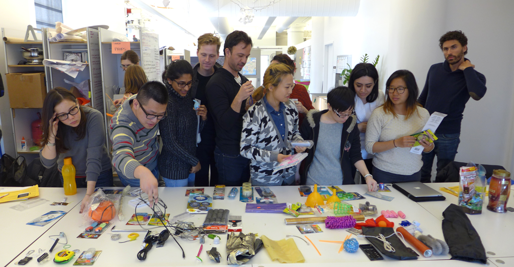
On December 3, 2017 WNYC organized a community workshop to prepare for the next storm with Midland Beach residents. The workshop was held at St. Christopher Community Center in Midland Beach and was facilitated by those interviewed for this story. More on the event can be watched below or read here.
This report is produced in collaboration with Peril and Promise, a public media initiative on the human impact of climate change from WNET.